How to Interpret Weather Patterns: A Practical Guide
Understanding the data your DIY weather station collects isn't just about seeing numbers; it's about deciphering a story the atmosphere is telling. This guide will help you translate your weather station readings into meaningful interpretations and even basic forecasting.
Understanding the Basics: Key Measurements
Before diving into patterns, let's recap the core readings from your weather station. These include:
- Temperature: Simple enough! Note trends – rising, falling, steady. Large swings often indicate instability.
- Humidity: Relative humidity tells you how much moisture is in the air compared to what the air *could* hold. High humidity combined with high temperature often leads to discomfort, and can be a precursor to precipitation. For a deeper understanding of how humidity is measured and what it signifies, check out understanding humidity.
- Barometric Pressure: This is crucial. Falling pressure often signals approaching low-pressure systems and potential stormy weather. Rising pressure indicates stable conditions.
- Wind Speed & Direction: Wind direction tells you where the air is coming from. Observing wind shifts can be a clue about approaching weather systems. Increased wind speeds are often associated with instability.
- Precipitation: The type and intensity of precipitation provide valuable information. Is it rain, snow, sleet, or hail? How heavy is it?
Recognizing Common Weather Patterns
Now, let’s look at how these measurements interact to reveal common weather patterns. We'll cover a few examples.
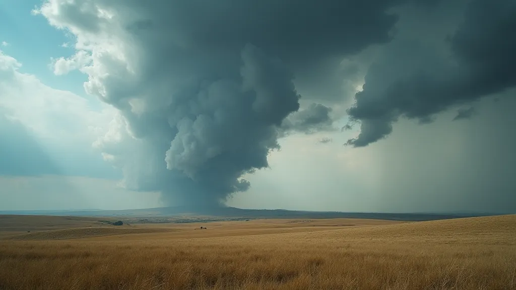
1. The Approaching Cold Front
A cold front marks the leading edge of a colder air mass. Here's what you might see:
- Barometric Pressure: Rapidly falling.
- Temperature: Falling, often noticeably so.
- Wind: Shifting direction, often from southwest to northwest.
- Clouds: Expect to see towering cumulonimbus clouds forming, potentially bringing showers or thunderstorms.
2. The High-Pressure System
High-pressure systems are generally associated with fair weather. Here’s what to look for:
- Barometric Pressure: Steadily rising.
- Temperature: Moderate, generally comfortable.
- Wind: Light and variable.
- Clouds: Few to no clouds.
3. The Warm Front
A warm front brings warmer air and can be more subtle than a cold front.
- Barometric Pressure: Slowly falling.
- Temperature: Gradually rising.
- Clouds: Expect to see widespread, layered clouds (stratus) that may bring drizzle or light rain.

Putting it all Together: Basic Forecasting
Forecasting isn’t about predicting the future with certainty, but about making educated guesses based on available data. Here's how to apply your weather station observations:
- Track Trends: Don’t just look at a single reading. Monitor how readings change over time. A gradual increase in temperature and humidity combined with falling pressure is a stronger indicator of impending rain than any single measurement.
- Consider Location: Your local geography plays a huge role. Proximity to mountains, bodies of water, and prevailing wind patterns will all influence your weather. Building and maintaining your weather station involves selecting the right tools and materials – for guidance on getting started with your DIY weather station: essential tools and materials, check out our detailed article.
- Compare with Regional Forecasts: Your weather station data is a great complement to professional weather forecasts. Compare your observations with what the experts are predicting.
Beyond the Basics
As you become more comfortable interpreting your weather station’s data, you can start exploring more advanced concepts such as:
- Dew Point: A more precise measure of humidity.
- Wind Shear: Changes in wind speed and direction with altitude.
- Atmospheric Stability: Understanding how stable or unstable the atmosphere is.
Connecting your weather station to the internet allows for real-time data monitoring and sharing. If you're interested in exploring simple options for internet connectivity, connecting your weather station to the internet (simple options) provides a step-by-step guide.
Like any piece of equipment, your weather station may encounter problems from time to time. Our troubleshooting common weather station problems article offers solutions to frequent issues and ensures your station continues to provide accurate data.
Understanding dew point is key to accurately assessing humidity and potential for precipitation. Dew point provides a more precise measurement than relative humidity alone, taking into account the actual amount of moisture in the air. It is essential for forecasting and understanding the impact of humidity on comfort and weather patterns.
The principles of atmospheric stability are crucial to weather forecasting. An unstable atmosphere is prone to convection, leading to thunderstorms and other severe weather events. Conversely, a stable atmosphere suppresses convection, leading to fair weather. Factors such as temperature, humidity, and wind shear influence atmospheric stability, and understanding these factors is essential for predicting weather patterns.
Wind shear, the variation in wind speed or direction with altitude, is an important factor in weather forecasting, particularly for aviation. Strong wind shear can create hazardous conditions for aircraft, causing turbulence and affecting flight paths. Understanding wind shear and its potential impact is essential for safe and efficient aviation.
Building and maintaining your weather station is a rewarding journey into the science of meteorology. Keep observing, keep learning, and enjoy the insights your station provides!